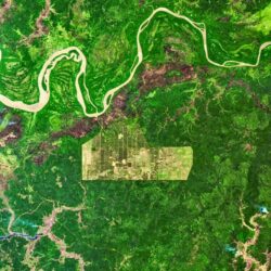
Satellite images combined with data provide hard evidence for deforestation-free products

How can you prove that goods have not been produced on deforested land? Public satellite images do not provide sufficient proof of deforestation-free products, Satelligence believes. For that, those images need to be combined with accurate data research. This is precisely the reason for it joining forces with ImpactBuying.
Producers and traders of coffee, soy and palm oil, among others, are all fervently collecting satellite images to prove that deforestation is not involved in their supply chains. However, the public sources they use for this purpose, such as Google Maps and the EU Forest Observatory, are not sufficiently reliable to comply with the deforestation law.
‘Public maps do not properly distinguish green plantations from green natural forest. Only with good global satellite coverage combined with an extensive local network can you determine what is actually growing, and avoid fines and hassle,’ says Niels Wielaard, CEO of Satelligence, which has been using satellite technology to track down deforestation for 25 years.
Huge amounts of data needed
From 30 December this year, the EU Deforestation Regulation (EUDR) law requires traders and producers to prove that their products were not produced on land that used to be forest. Because supply chains are often complex, with many middlemen or combinations of products coming from many different pieces of land, huge amounts of data are needed to comply with the law.
However, collecting data alone is not enough, believes Leontien Hasselman-Plugge, CEO of ImpactBuying and a specialist in supply chain data. This company analyses A-brand supply chains worldwide and helps retailers make their supply chains transparent. ‘The challenge lies in making sure the data is demonstrably reliable and thoroughly checked. Not just the data from the farmers themselves, but also from all the middlemen and suppliers, who, for example, add things to the products,’ says Hasselman-Plugge.
Hard evidence rather than estimates
Deforestation can only be countered if farmers and retailers work closely together throughout their supply chains, argue Wielaard and Hasselman-Plugge. Satelligence and ImpactBuying are therefore joining forces. By combining satellite imagery with accurate data research, they focus on hard evidence rather than risk assessments, which is what they say often happens. Data from the silos of major traders, producers and retailers will be linked to detect deforestation.
Hasselman-Plugge: ‘Globally, there is still a lot of forest being cleared. The European anti-deforestation law will not put an end to this, but it is an important step in the right direction. As the saying goes, “The best time to plant a tree was 20 years ago. The second best time is now”. The same holds true for stopping cutting trees down.’


